
Los Angeles, CA—DJI announced a new drone rescue-related milestone was reached in recording the importance of drone technology in search and rescue missions. Statistics compiled by the provider of civilian drones and aerial imaging technology show drones were directly involved in saving more than 1,000 people from danger around the world.
One of the most recent examples involved two hikers in New York State who lost their way at nightfall. Moreover, they were unable to lead rescuers to their location as their phone battery ran low. The Sheriff’s Office UAS unit finally found them with the help of a drone employing a thermal camera.
“Drones are an essential lifesaving tool for search and rescue operators around the world. It is encouraging to see how civilians with drones often volunteer to help in critical emergencies,” said Christina Zhang, DJI’s senior director of Corporate Strategy. “Since we started compiling drone rescue statistics in 2017, we have made it our mission to share with the world how important drone technology is for the men and women who put their lives on the line for us all to save people from serious harm.”
Drone Rescue-Related Milestone
Drones often prove the key device needed to save people whose lives are in grave danger. In July 2022, a teenager swimming in the sea on the east coast of Spain struggled to return to shore because of strong currents. A UAS lifeguard service in operation across Spanish beaches used a drone to drop a life vest to the exhausted youth. The vest saved the 14 year old from drowning before rescuers reached him.
A more unusual rescue involved a man stuck in snow in Oregon in remote terrain without phone reception. He attached his phone to his drone and launched it into the air to deliver an SOS-message identifying his exact location. Rescuers found him and two other people and brought them to safety.
Drone Rescue Map
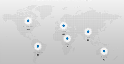
Furthermore, the DJI Drone Rescue Map tracks incidents when police, firefighters, rescue squads and bystanders have used drones to save people from danger. It includes all known events since the first recorded rescue in 2013. DJI compiles drone rescues from news stories and social media posts from authoritative sources such as police departments, fire departments and volunteer rescue squads.
The company enters each incident on the Drone Rescue Map. It includes the location and date as well as a brief description. DJI also includes a link to the original story or post and an easy way to share those incidents online.
However, DJI’s tally don’t include incidents when a drone is used as part of a larger search process. Instead, a drone must have directly located, assisted and/or rescued a person in peril.
“We are grateful that civilian drones have saved so many people around the world,” said Adam Welsh, DJI Global Head of Policy. “We appeal to the public and other stakeholders in society to spread the word how drones can really help and that restricting rescue agencies’ access to this technology because of lack of funding or for other reasons puts lives at risk.”
DJI encourages the public and search and rescue teams to add their stories of drone rescues. They can submit them using the form at the bottom of the map page.


